Neighbouring areas · Guide two of three
Dartmouth Park & Kentish Town
Victorian villas on the slope below Highgate, a Georgian terrace listed Grade II*, and the Heath across the road. A conservation area with almost none of the extra controls that NW3 buyers have learned to expect.
- Postcode
- NW5With the upper ends of some streets running into N19
- Conservation area
- Since 1992Dartmouth Park, designated 4 February 1992
- Article 4 on houses
- NoneThe only direction protects a painted sign
- Stations
- FourNorthern line, Thameslink and the Overground, all in Zone 2
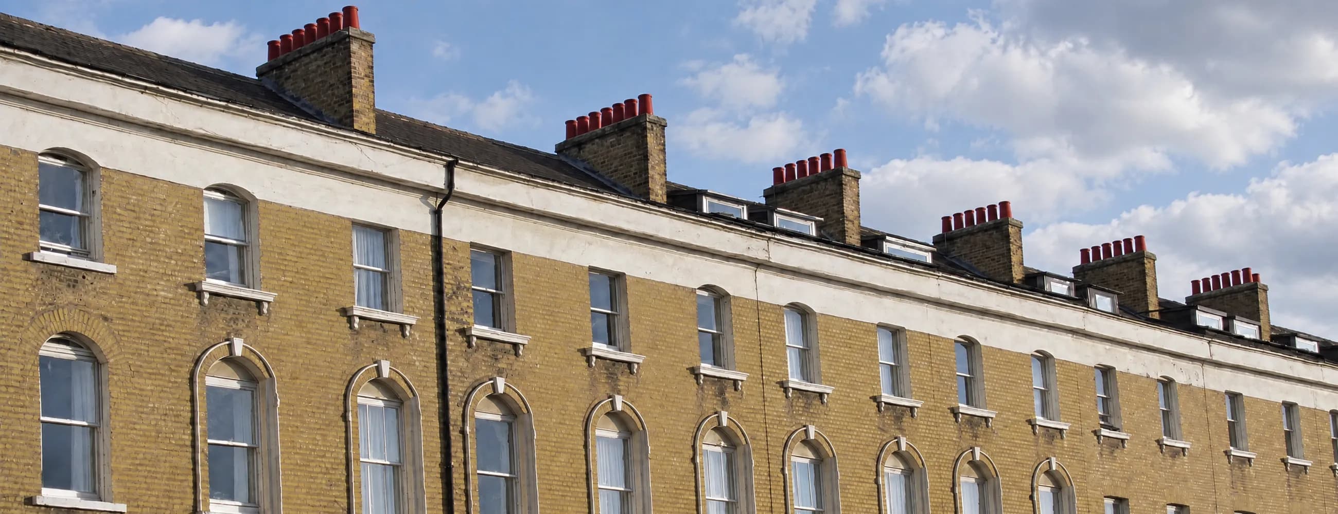
Victorian stock brickMost of Dartmouth Park and Kentish Town went up between 1840 and 1890: yellow stock brick terraces and villas, many with semi-basements, under a long line of chimney stacks. The oldest houses, a Georgian terrace of 1777 to 1824, stand on Highgate Road.
Every factual claim on this page was checked against the sources below on .
Camden Council · conservation areas, Article 4 directions, the neighbourhood plan, admissions, parkingDepartment for Education · every named schoolHistoric England · listed buildings, grades and the at risk registerTransport for London · lines, zones and the station reopeningHM Land Registry · the live sales figures
Planning rules change. Camden replaced several conservation area Article 4 directions in June 2026. None of them covers Dartmouth Park or Kentish Town, but confirm anything that turns on a planning instrument against the current position before you act on it.
Streets and characterTen sub areas, a buried river, and very few extra rules.
Victorian villas, 1920s and 1930s estates, and the one Article 4 direction
Camden designated the Dartmouth Park Conservation Area on 4 February 1992 and adopted its appraisal and management strategy on 22 January 2009. A stretch of Highgate Road, first designated in 1985 as part of the Highgate conservation area, moved into it at designation, and Holly Village and the shops near Highgate West Hill followed on 21 March 2006.
The appraisal says most of its properties were built between 1840 and 1890, and it is clear about who built them. In the 1850s the Conservative Land Society bought land to the east and laid out Churchill, Spencer and Chetwynd Roads. In the 1860s Lord Dartmouth developed the land behind Grove Terrace to create Dartmouth Park Road, with spacious gardens and street trees. A local builder named Smerdon built Croftdown Road on the gardens of Croft Lodge, and much of the east end of Dartmouth Park Road and Laurier Road besides. Under all of it, a branch of the River Fleet runs along the central valley, culverted in the 1890s, which is why York Rise follows the line it does.
It is not all Victorian. The appraisal divides the area into ten sub areas, and several are twentieth century: the Brookfield Estate, designed for St Pancras Borough Council between 1922 and 1930 by A. J. Thomas, Lutyens’ principal assistant, on the model of Hampstead Garden Suburb; the York Rise Estate, completed in 1938 for the St Pancras House Improvement Society; the Edwardian mansion flats of Lissenden Gardens; and the 1970s Camden estates at Highgate New Town and the Whittington Estate.
What you may change
This is the point that most surprises buyers coming from NW3. Camden’s list of heritage Article 4 directions has only one for Dartmouth Park, made on 7 March 1980, and it does one thing: it removes the right to paint the outside of 33 York Rise, to preserve a painted sign on its flank wall. The replacement directions Camden brought in on 9 June 2026 covered Hampstead, Belsize, South Hampstead and their neighbours, not Dartmouth Park or Kentish Town.
So houses here have the ordinary permitted development rights of a conservation area and nothing beyond that. Two things still apply everywhere: a borough wide Article 4 direction means every basement excavation in Camden needs planning permission, and the Dartmouth Park Neighbourhood Plan, made on 2 March 2020 after 87.9 per cent voted for it, carries weight in planning decisions. The protected London view from Kenwood to St Paul’s also crosses the western part of the area.
Kentish Town
South of Dartmouth Park, Kentish Town is covered by several smaller conservation areas rather than one: Kentish Town itself, with an appraisal adopted on 11 March 2011, and Bartholomew Estate, Inkerman, West Kentish Town and Camden Square around it. Camden’s pages list no heritage Article 4 directions for any of them.
Planning position as at 22 September 2026
The Dartmouth Park Conservation Area was designated on 4 February 1992, and most of its houses were built between 1840 and 1890. Its only Article 4 direction, from 1980, protects a painted sign on 33 York Rise, so houses keep the ordinary permitted development rights of a conservation area. Every basement in Camden needs planning permission, and the neighbourhood plan made in 2020 carries weight in decisions.
- Grove TerraceTwenty seven houses built 1777 to 1824, set back from Highgate Road. Nos 6 to 27 are Grade II*.Highgate Road sub area
- Dartmouth Park RoadThree storey semi-detached villas with semi-basements at the west end, Smerdon semis of 1884 to 1889 at the east.Dartmouth West and East
- Dartmouth Park AvenueCalled one of the grandest streets in the area: large late Victorian villas.Dartmouth East
- Chetwynd RoadLaid out by the Conservative Land Society. Narrow fronted terraces close to the pavement.Dartmouth Park CA
- Twisden RoadPairs of terraced houses stepping down the slope. An exceptionally well preserved roofline.Dartmouth Park CA
- Laurier RoadTerraces at the short west end, mostly Smerdon semis with views to Hampstead at the east.Dartmouth West and East
- Croftdown RoadBuilt by Smerdon on the gardens of Croft Lodge. Its sweep marks the edge of the Brookfield Estate.Dartmouth Park CA
- York RiseFollows the buried branch of the Fleet. Home to the 1938 York Rise Estate, and to the one Article 4 direction.Dartmouth Park CA
- Spencer RiseBuilt for artisans, mostly in the 1870s. Simpler and less detailed than its neighbours.Dartmouth Park CA
- Leverton StreetColoured stucco houses behind narrow front gardens.Kentish Town CA
- Lady Margaret RoadUniform terraces of generous proportions.Kentish Town CA
Grove TerraceA Georgian terrace, almost complete, on the edge of the Heath.
1772, Lord Dartmouth, and one of the best Georgian survivals in north London
In 1772 Lord Dartmouth, a major copyholder, enclosed part of the common beside Highgate Road. Grove Terrace was built on the land it released, between 1777 and 1824, and it is still there: twenty seven houses set back from Highgate Road.
Historic England lists Nos 6 to 27 at Grade II*, with their railings and lamp holders, and Nos 1 to 5 at Grade II; both entries date from 10 June 1954. Camden’s appraisal calls the terrace an unusually comprehensive survival of eighteenth century speculative development. The houses are stock brick, most of three storeys and attics, with Doric doorcases, fanlights, cast iron balconies and railings with urn finials, and several keep their iron lamp holders over the steps.
For a buyer, Grade II* is a serious designation. Listed building consent is needed for alterations inside as well as out, and it is the grade Historic England gives to buildings of more than special interest. Houses in the terrace come up rarely, and when they do the survey and the listing file matter as much as the asking price.
The neighbours
The same stretch of north London has three more listings a buyer here will know. Holly Village, twelve Gothic houses of 1865 built for Baroness Burdett-Coutts, is Grade II*. The Church of St Mary Brookfield on Dartmouth Park Road, by William Butterfield, is Grade II* and on Historic England’s Heritage at Risk Register. And the Parliament Hill Fields Lido, built for the London County Council in 1937 to 1938, is Grade II.
Grove Terrace on Highgate Road was built between 1777 and 1824 on land Lord Dartmouth enclosed in 1772. Nos 6 to 27 are listed Grade II* and Nos 1 to 5 Grade II. Holly Village and the Church of St Mary Brookfield nearby are also Grade II*, and the Parliament Hill Fields Lido is Grade II.
- Grove Terrace, Nos 6 to 27 About 1780 to 1793, with railings and lamp holders Grade II*
- Grove Terrace, Nos 1 to 5 Early nineteenth century, stucco ground floors and porticoes Grade II
- Holly Village 1865, by H. A. Darbishire for Baroness Burdett-Coutts Grade II*
- St Mary Brookfield William Butterfield, 1869 to 1875. On the at risk register Grade II*
- Parliament Hill Fields Lido 1937 to 1938, for the London County Council Grade II
Schools and admissionsFour secondary schools within a short walk, and one shared sixth form.
No catchment areas, two closures, and how each school admits
For secondary schools this is one of the best placed corners of Camden. Parliament Hill School, William Ellis School and La Sainte Union Catholic Secondary School all stand on Highgate Road, and Acland Burghley School is on Burghley Road. Parliament Hill and La Sainte Union take girls at 11 and William Ellis takes boys, but all four share the LaSWAP sixth form, which is mixed.
Camden has no catchment areas. Its admissions guides say its primary schools have none, apart from Abacus Belsize Free School, and that its community secondary schools have none and no feeder primaries. Community schools rank applicants by straight line distance after the priority groups, and Camden publishes the distance to the furthest child offered a place each year. That figure is a record of one year and not a boundary. Voluntary aided schools set their own criteria: La Sainte Union gives priority to Catholic applicants, and William Ellis offers some places for aptitude in music.
Two names that still appear in older guides are gone. Carlton Primary School closed in August 2021 and St Dominic’s Catholic Primary School closed in August 2023.
Admissions position as at 22 September 2026
Applications for September 2027 close on 31 October 2026 for secondary schools and on 15 January 2027 for reception. Check the current arrangements with Camden and with each school before you rely on anything here.
Parliament Hill, William Ellis and La Sainte Union stand on Highgate Road and Acland Burghley is on Burghley Road, and all four share the mixed LaSWAP sixth form. Camden has no catchment areas for its community schools, which admit by straight line distance after the priority groups. Carlton Primary and St Dominic’s Catholic Primary have both closed.
- Brookfield Primary School Mixed, 2 to 11. Chester Road Proximity
- Eleanor Palmer Primary School Mixed, 3 to 11. Lupton Street Proximity
- Gospel Oak Primary School Mixed, 3 to 11. Mansfield Road Proximity
- Torriano Primary School Mixed, 3 to 11 Proximity
- Rhyl Community Primary School Mixed, 2 to 11 Proximity
- Kentish Town Church of England Primary School Mixed, 3 to 11 CofE
- Parliament Hill School Girls at 11. Mixed LaSWAP sixth form Proximity
- William Ellis School Boys at 11. Mixed LaSWAP sixth form Music places
- La Sainte Union Catholic Secondary School Girls at 11. Mixed LaSWAP sixth form Catholic first
- Acland Burghley School Mixed, 11 to 18. Burghley Road Proximity
- The Camden School for Girls Girls at 11. Sandall Road Ability bands
- Highgate School Mixed, 3 to 19. North Road, Haringey Selective
Phase, age range and gender of intake as recorded by the Department for Education. Admission arrangements, published distances and fees change every year. Check the current position with Camden and with each school directly before you rely on it.
Transport and parkingFour stations in Zone 2, and Thameslink straight through the City.
The Northern line, Thameslink, two Overground lines, and Camden permits
Kentish Town is the station that matters most. It is in Zone 2 and has both the Northern line and Thameslink, which runs through St Pancras and the City without a change. The Underground station closed in June 2023 for new escalators and reopened on 23 December 2024.
Tufnell Park, also on the Northern line and in Zone 2, is the nearer station for the eastern streets of Dartmouth Park. To the west, Gospel Oak is on two Overground lines, the Mildmay and the Suffragette, and Kentish Town West is on the Mildmay line. All four are in Zone 2.
Parking
The whole area is in Camden’s controlled parking zones. Camden prices resident permits by the duration of the permit, fuel type and CO2 emissions band, with an air quality surcharge on older petrol and diesel vehicles, and since 1 October 2024 each permit covers one vehicle. You must live at the address at least five nights a week, the car must be registered and insured in your name there, and homes with a car free or car capped agreement cannot have a permit.
Zone names and hours vary street by street, so check Camden’s parking map or the zone entry sign. Prices change each April, so read Camden’s own permit charges page rather than any figure printed elsewhere.
Kentish Town station, in Zone 2, has the Northern line and Thameslink, and reopened on 23 December 2024 after new escalators were fitted. Tufnell Park is on the Northern line, Gospel Oak on the Overground Mildmay and Suffragette lines, and Kentish Town West on the Mildmay line, all in Zone 2. Street parking needs a Camden resident permit.
- Kentish Town Northern line and Thameslink Zone 2
- Tufnell Park Northern line Zone 2
- Gospel Oak Overground, Mildmay and Suffragette lines Zone 2
- Kentish Town West Overground, Mildmay line Zone 2
What things sell forHouses first, and the Heath end of the slope at the top.
What the stock is, and where the premiums and the discounts sit
The stock is mostly Victorian stock brick villas and terraces, many of them now flats, with the Georgian houses of Grove Terrace and Highgate Road at one end of the scale, the Edwardian mansion flats of Lissenden Gardens in the middle, and the 1920s, 1930s and 1970s estates at the other.
Values are highest in the Georgian terraces and in the larger villas on Dartmouth Park Avenue and the west end of Dartmouth Park Road, and generally rise the closer a house sits to the Heath and Parliament Hill. Side streets trade above the main roads: a flat on Highgate Road or Kentish Town Road usually sells at a discount to the same flat a street away.
The absence of Article 4 control is worth weighing in both directions. It makes altering your own house simpler than in most of NW3, and it means the street around you is protected only by the ordinary conservation area rules. An intact run of original fronts is therefore worth something here, and a surveyor’s view of a neighbour’s alterations is worth having.
This section is Tessa’s reading of the market, not a sourced fact. For a figure on a particular home, ask her.
Figures, London Borough of Camden
- Detached £3,606,000
- Semi-detached £2,125,000
- Terraced £1,569,000
- Flats and maisonettes £688,000
- All property types £833,000
Live: sales on this guide’s streets
- Sales in the 12 months to August 2026 28
- Median price, all sales £798,500
- Flats and maisonettes, median of 19 £530,000
- Terraced, median of 6 £1,497,500
Everything factual on this page comes from a public source. Conservation areas, Article 4 directions, the neighbourhood plan, admissions and parking: Camden Council. Listings and the at risk register: Historic England. Schools: the Department for Education’s Get Information about Schools. Stations: Transport for London. Prices: the Office for National Statistics and HM Land Registry.
Common questionsEight things people ask before they view.
Short, sourced answers on the conservation area, Article 4, listings, schools and stations
Is Dartmouth Park a conservation area?
Yes. Camden designated the Dartmouth Park Conservation Area on 4 February 1992, and Holly Village and the shops near Highgate West Hill joined it on 21 March 2006. Camden adopted its appraisal and management strategy on 22 January 2009, and it divides the area into ten sub areas.
Do Article 4 directions apply to houses in Dartmouth Park?
No. Camden lists only one direction for Dartmouth Park, made on 7 March 1980, which protects a painted sign on 33 York Rise. The replacement directions Camden brought in on 9 June 2026 covered Hampstead, Belsize and South Hampstead, not Dartmouth Park or Kentish Town. Ordinary conservation area controls and the borough wide basement direction still apply.
Do I need planning permission for a basement?
Yes. A borough wide Article 4 direction means every basement excavation in Camden needs planning permission, and that includes Dartmouth Park and Kentish Town.
Which buildings in Dartmouth Park are listed?
Grove Terrace on Highgate Road is the best known: Nos 6 to 27 are Grade II* and Nos 1 to 5 are Grade II. The Church of St Mary Brookfield on Dartmouth Park Road, by William Butterfield, is Grade II* and on the Heritage at Risk Register, and Holly Village is Grade II*.
Does Camden have school catchment areas?
No. Camden says its primary schools have no catchment areas, apart from Abacus Belsize Free School, and that its community secondary schools have none and no feeder primaries. Community schools rank applicants by straight line distance, and the published furthest distance changes every year.
Which secondary schools are closest?
Parliament Hill School for girls, William Ellis School for boys and La Sainte Union Catholic Secondary School for girls all stand on Highgate Road, and Acland Burghley School, which is mixed, is on Burghley Road. All four share the LaSWAP sixth form, which is mixed.
Is Kentish Town station open?
Yes. The Underground station closed in June 2023 for new escalators and reopened on 23 December 2024. Kentish Town is in Zone 2 and has both the Northern line and Thameslink.
Is there a neighbourhood plan?
Yes. The Dartmouth Park Neighbourhood Plan was made on 2 March 2020, after 87.9 per cent voted for it in a referendum on 6 February 2020. It carries weight in planning decisions in the area.
Thinking of selling in Dartmouth Park?
An honest figure based on what has actually sold on your street this year, not a number designed to win the instruction and then be reduced in six weeks. Valuation, viewings, negotiation and progression, all with the same person.
Tessa will get back to you as soon as possible.