Neighbouring areas · Guide one of three
West Hampstead
A London village strung along one winding lane, with three railway stations inside a few hundred metres of each other. The conservation rules here are lighter than in NW3, and they change from one side of the Lane to the other.
- Postcode
- NW6With the Fordwych Road side and Hampstead School in NW2
- Conservation area
- Since 1993West End Green, designated 17 March 1993
- Neighbourhood plan
- 2015Adopted after a 93 per cent yes vote
- Stations
- ThreeJubilee line, Overground and Thameslink, all in Zone 2
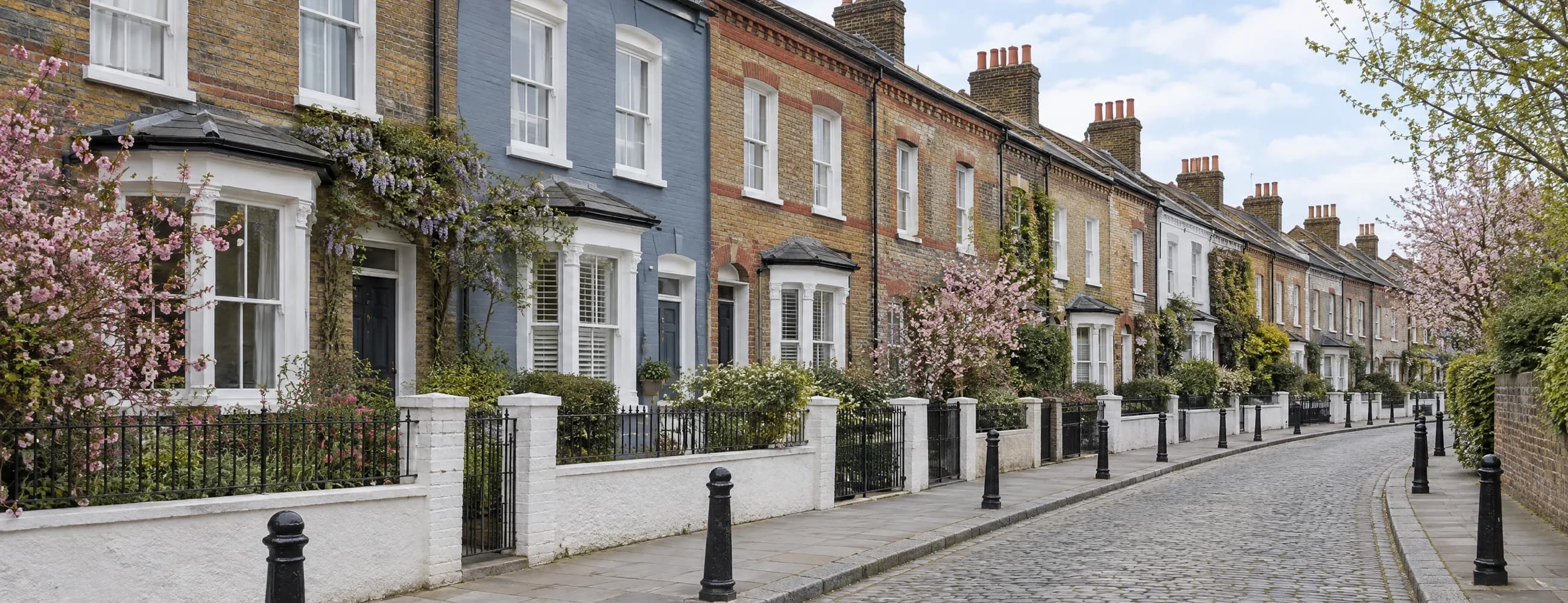
Victorian terracesMost of West Hampstead went up in the last two decades of the nineteenth century, after the railways arrived: long terraces to the west of the Lane, larger red brick houses to the east, and mansion blocks above the shops.
Every factual claim on this page was checked against the sources below on .
Camden Council · conservation areas, Article 4 directions, the neighbourhood plan, admissions, parkingDepartment for Education · every named schoolHistoric England · listed buildings, grades and the registered cemeteryTransport for London · lines and line namesVictoria County History · builders and building datesHM Land Registry · the live sales figures
Planning rules change. Camden replaced several conservation area Article 4 directions in June 2026, including the one for South Hampstead, which covers the east side of West End Lane. Confirm anything that turns on a planning instrument against the current one before you act on it.
Streets and characterOne lane, two conservation areas, and a good deal that is in neither.
Which side of West End Lane a house stands on decides which rules apply to it
Camden’s own appraisal describes West End Green as “a London village running along the spine of the West End Lane”, and that is a fair summary of the whole place. The Lane winds along the line of an ancient route, with shops at street level and mansion blocks above, and the residential streets run off it on both sides.
Almost all of it was built in a hurry. The Midland Railway station opened on West End Lane in 1871, the Metropolitan followed in 1879, and most of the buildings in the conservation area date from the last two decades of the nineteenth century and the first few years of the twentieth. The Victoria County History records the builders by name: W. H. Suttle put up 155 houses on Agamemnon, Ajax, Ulysses and Achilles Roads between 1886 and 1896, and 346 houses went up around Sumatra Road between 1882 and 1894.
West End Green Conservation Area
The heart of West Hampstead is the West End Green Conservation Area, designated on 17 March 1993 together with the then separate Parsifal Road area. A review in 2010 to 2011 extended it to join the two parts, and Camden adopted the appraisal on 28 February 2011. It runs from Finchley Road in the north to the Thameslink station in the south, and the appraisal divides it into six character areas: the Lane itself, the Green and West Cottages, the terraces to the west, Parsifal Road and Lyncroft Gardens, the larger houses to the east, and the mansion blocks.
There is no Article 4 direction here. The 2011 management strategy recommended directions covering front gardens, boundaries, windows, doors and shopfronts, but none was ever made, and Camden’s list of heritage directions includes none for West End Green. Ordinary conservation area controls apply to houses, and the appraisal says the council will normally resist basements that front the street.
South Hampstead, across the Lane
Broadhurst Gardens and the east side of West End Lane south of the Tube station fall in the South Hampstead Conservation Area, the one covered in the Swiss Cottage guide. Its Article 4 direction was amended with effect from 9 June 2026, and Camden’s fact sheet says planning permission is now needed for work to fronts and street facing sides: windows and doors in a different material or design, porches and front walls, painting brick that has not been painted before, front rooflights, chimneys and front hard surfacing. It covers houses converted to flats as well as whole houses. Like for like repair is exempt, and there is no fee for an application the direction requires.
Outside both
Fortune Green and the Greek streets are not in any conservation area. Camden proposed a Fortune Green conservation area in 2011, and the neighbourhood plan proposed it again in 2015, but it was never designated. That makes the terraces around Agamemnon Road some of the least regulated period houses in this part of Camden, which cuts both ways: more freedom to alter your own house, and less protection from what a neighbour does to theirs.
Rules that apply everywhere
Two instruments cover all of it. A borough wide Article 4 direction means every basement excavation in Camden needs planning permission. And the Fortune Green and West Hampstead Neighbourhood Plan, backed by 93 per cent of voters on 9 July 2015 and adopted on 16 September 2015, carries weight in planning decisions until 2031, including on building heights, materials and the green spaces it protects.
Planning position as at 22 September 2026
The centre of West Hampstead is the West End Green Conservation Area, designated in 1993, which has no Article 4 direction. Broadhurst Gardens and the east side of West End Lane south of the Tube are in South Hampstead, where a direction amended in June 2026 controls front windows, doors, rooflights and chimneys. Fortune Green and the Greek streets are in no conservation area at all. Every basement in Camden needs planning permission.
- West End LaneThe spine. Shops below, mansion blocks above, and all three stations.West End Green, and South Hampstead on the east side south of the Tube
- Crediton HillLaid out about 1897, with large detached houses.West End Green
- Parsifal RoadLarge double fronted red brick houses from the 1890s. Once the separate second part of the area.West End Green
- Lymington RoadLarge semi-detached red brick houses behind random stone garden walls.West End Green
- Fawley RoadThe same idiom as Lymington Road, and the same walls.West End Green
- Dennington Park RoadLaid out about 1881. The library and the Grade II* synagogue stand at its corner with the Lane.West End Green
- Fortune Green RoadRuns north from the Green past Hampstead Cemetery.Southern end only in West End Green
- Mill LaneAn old route meeting the Green, with its own shops and 1920s blocks of flats.Eastern end only in West End Green
- Sumatra RoadPart of the 346 houses built around it between 1882 and 1894.Mostly outside
- Agamemnon RoadWith Achilles and Ulysses Roads, the Greek streets: two storey terraces with carved faces on the bay capitals.No conservation area
- Achilles RoadBuilt by W. H. Suttle, 1886 to 1896, like the rest of the Greek streets.No conservation area
- Ulysses RoadThe same builder and the same decade.No conservation area
- Gondar GardensThree storey terraces with a distinctive diagonal glazing pattern.No conservation area
Three stationsThree railways, one lane, and the reason West Hampstead exists.
1871, 1879 and 1888, and what each line is for now
West Hampstead was a hamlet called West End until the railways came, and then it was built out in about thirty years. The stations that caused that are still the thing that sets it apart. Three of them sit on West End Lane within a few minutes’ walk of each other, all in Zone 2, on three different lines going in three different directions.
West Hampstead Thameslink is the oldest. It opened on 1 March 1871 as a Midland Railway station, and Camden’s appraisal dates the area’s growth from it. Thameslink now runs north to St Albans, Luton and Bedford and south through the City to Brighton and beyond,
West Hampstead Underground opened on 30 June 1879 on the Metropolitan Railway and is now on the Jubilee line, which reaches Bond Street, Westminster, London Bridge and Canary Wharf without a change. It is not yet step free: Transport for London announced in 2024 that design work on step free access would begin.
West Hampstead Overground is on what TfL renamed the Mildmay line in November 2024, running west to Richmond and Clapham Junction and east to Stratford.
For a buyer, the practical point is that almost any journey in London starts with one change or none. The cost is that the stations and the railway cuttings run straight through the middle of the area, and houses backing onto a line are a different proposition from those a street away.
The Green itself
West End Green, where Mill Lane meets the Lane, gives the conservation area its name. Its granite drinking fountain of 1897, put up by a Miss Miles in memory of a mother who had lived in West End for 76 years, is listed Grade II, and so is the fire station of 1901 a short way along West End Lane.
Three stations stand on West End Lane, all in Zone 2: the Underground on the Jubilee line, opened in 1879; the Overground on the Mildmay line to Richmond, Clapham Junction and Stratford; and Thameslink, opened in 1871, running north to Bedford and south through the City. The Underground station is not yet step free.
- Hampstead Synagogue Dennington Park Road. Delissa Joseph, 1892 to 1901 Grade II*
- Fire station 325 West End Lane, 1901, by the LCC Fire Brigade Branch Grade II
- Emmanuel Church Lyncroft Gardens, 1897 to 1898 Grade II
- Drinking fountain West End Green, 1897, granite, with a dog trough Grade II
- Church of St James Sherriff Road. A. W. Blomfield, 1887 to 1888 Grade II
- Hampstead Cemetery Fortune Green Road, opened November 1876. A registered park and garden Grade II
Schools and admissionsDistance decides most of it, and the published distances are short.
Community, Church of England and Catholic primaries, and how each one admits
Camden has no school catchment areas, with one exception elsewhere in the borough: Camden’s own admissions guide says that other than at Abacus Belsize Free School, its primary schools do not have them. After looked after children, siblings, exceptional need and children of staff, community schools admit by straight line distance from home. Each year Camden publishes the distance to the furthest child offered a place, which is a record of that year and not a boundary.
Church schools are different, and the one most West Hampstead families ask about shows why. Emmanuel Church of England Primary School on Mill Lane gives two thirds of its places, after the priority groups, to families who meet its worship criteria and one third on open distance. Its own 2026 allocation records 157 applications for 30 places, with the last open place going to a child 0.037 miles away. Whenever a distance is quoted, check which year and which route it belongs to.
One name has changed. The school on Dornfell Street is now West Hampstead Primary School, having been Beckford Primary School until it was renamed after 2020.
Admissions position as at 22 September 2026
Applications for September 2027 close on 31 October 2026 for secondary schools and on 15 January 2027 for reception. Check the current arrangements with Camden and with each school before you rely on anything here.
Camden has no catchment areas for its primary schools apart from Abacus Belsize Free School, and community schools admit by straight line distance after the priority groups. Emmanuel CofE Primary on Mill Lane gives two thirds of its places on faith and one third on distance. Beckford Primary is now called West Hampstead Primary School.
- West Hampstead Primary School Mixed, 3 to 11. Dornfell Street. Formerly Beckford Proximity
- Kingsgate Primary School Mixed, 3 to 11. Two sites, measured from a point between them Proximity
- Emmanuel Church of England Primary School Mixed, 3 to 11. Mill Lane CofE, two thirds faith
- St Mary’s Kilburn Church of England Primary School Mixed, 3 to 11. Quex Road CofE
- St Eugene de Mazenod Roman Catholic Primary School Mixed, 4 to 11. Mazenod Avenue Catholic
- Hampstead School Mixed, 11 to 18. Westbere Road, NW2 Proximity
- South Hampstead High School Girls, 4 to 19. Maresfield Gardens Selective
- University College School Mixed, 4 to 18. Frognal Selective
- The Mulberry House School Mixed, 2 to 7. Minster Road, NW2 Pre-prep
Phase, age range and gender of intake as recorded by the Department for Education. Admission arrangements, published distances and fees change every year. Check the current position with Camden and with each school directly before you rely on it.
Transport and parkingBetter connected than anywhere in NW3, and parked accordingly.
Three lines in Zone 2, and Camden resident permits
The stations are covered above. In short: the Jubilee line for the West End, Westminster and Canary Wharf, Thameslink for St Pancras and the City, and the Overground for an orbital run west to Richmond or east to Stratford. Few London addresses have three lines at the end of the street.
Parking
West Hampstead is inside Camden’s controlled parking zones. Camden prices resident permits by the duration of the permit, the vehicle’s CO2 emissions band and its fuel type, with an air quality surcharge on older petrol and diesel vehicles and none on electric ones. You must live in the borough at least five nights a week, the car must be registered and insured in your name, and a home built under a car free or car capped agreement cannot have a permit, which matters for a good number of the newer flats near the stations.
Which zone covers a given street, and its hours, is best checked on Camden’s parking map or on the zone entry sign rather than assumed. Prices change each April, so Camden’s own permit charges page is the one to read.
Three Zone 2 stations on West End Lane give the Jubilee line, Thameslink and the Overground Mildmay line. Street parking needs a Camden resident permit, priced by duration, CO2 band and fuel type, with a surcharge on older petrol and diesel cars. Homes built as car free cannot have one.
- West Hampstead Jubilee line Zone 2
- West Hampstead London Overground, Mildmay line Zone 2
- West Hampstead Thameslink Thameslink, north to Bedford, south through the City Zone 2
What things sell forMostly flats, some very good houses, and the stations priced in.
Four kinds of housing, and where the premiums and the discounts sit
The housing falls into four groups, and they trade very differently. Mansion block flats, mostly from the 1890s and 1900s around West End Lane and Cannon Hill, with the 1920s blocks on Mill Lane and Cholmley Gardens. Late Victorian terraces of two and three storeys to the west, in the Greek streets and around Sumatra Road. Larger semi-detached and detached houses to the east, on Crediton Hill, Parsifal Road, Lymington Road and Fawley Road. And across the Lane, the big South Hampstead houses, most of them long since converted to flats.
Flats, converted or purpose built, make up most of what changes hands. The whole houses east of the Lane are the scarce stock and the top of the local market. The Greek street terraces are where families buy a whole house for a good deal less than the equivalent would cost in NW3.
The premiums are the usual ones plus the stations: a short, level walk to all three, a quiet street off the Lane, and an intact period front. The discounts are positions backing onto the railway, frontage onto West End Lane or Finchley Road, short leases, and, on the South Hampstead side, front windows or rooflights changed without the consent the direction now requires.
This section is Tessa’s reading of the market, not a sourced fact. For a figure on a particular home, ask her.
Figures, London Borough of Camden
- Detached £3,606,000
- Semi-detached £2,125,000
- Terraced £1,569,000
- Flats and maisonettes £688,000
- All property types £833,000
Live: sales on this guide’s streets
- Sales in the 12 months to August 2026 57
- Median price, all sales £675,000
- Flats and maisonettes, median of 50 £627,500
- Terraced, median of 6 £1,615,000
Everything factual on this page comes from a public primary source. Conservation areas, Article 4 directions, the neighbourhood plan, admissions and parking: Camden Council. Listings and the cemetery’s registration: Historic England. Schools: the Department for Education’s Get Information about Schools. Lines: Transport for London. Prices: the Office for National Statistics and HM Land Registry.
Common questionsEight things people ask before they view.
Short, sourced answers on the conservation areas, basements, stations, schools and parking
Is West Hampstead in a conservation area?
The heart of it is. The West End Green Conservation Area was designated on 17 March 1993 and covers West End Lane, West End Green and nearby streets such as Crediton Hill, Parsifal Road and Dennington Park Road. Broadhurst Gardens and the east side of West End Lane south of the Tube station are in the South Hampstead Conservation Area instead. Fortune Green and the Greek streets are not in any conservation area.
Do I need permission to change the windows on a West Hampstead house or flat?
It depends which side of the Lane it is on. West End Green has no Article 4 direction, so ordinary conservation area permitted development rules apply to houses. In South Hampstead, a direction amended on 9 June 2026 means you need permission to replace front windows or doors with a different design or material, and it covers houses converted to flats. Like for like replacement does not need permission, and there is no fee for applications the direction requires.
Can I dig a basement?
Not without planning permission. A borough wide Article 4 direction means every basement excavation in Camden needs planning permission, and the West End Green appraisal says the council will normally resist basements that front the street.
Which stations serve West Hampstead?
Three, all in Zone 2 and all on West End Lane. The Underground station is on the Jubilee line, the Overground station is on the Mildmay line to Richmond, Clapham Junction and Stratford, and Thameslink runs north to Bedford and Luton and south through the City. The Underground station is not yet step free.
Is there a school catchment area in West Hampstead?
No. Camden says its primary schools have no catchment areas, apart from Abacus Belsize Free School, and community schools rank applicants by straight line distance after the priority groups. Each year Camden publishes the distance to the furthest child offered a place, which is a record of that year and not a boundary.
Which state primary schools are nearest?
West Hampstead Primary School on Dornfell Street, formerly Beckford Primary School, and Kingsgate Primary School are community schools for ages 3 to 11. Emmanuel Church of England Primary School on Mill Lane is voluntary aided and gives two thirds of its places, after the priority groups, to families who meet its worship criteria and one third on distance.
Is there a neighbourhood plan?
Yes. The Fortune Green and West Hampstead Neighbourhood Plan was backed by 93 per cent of voters on 9 July 2015 and adopted by Camden on 16 September 2015. It carries weight in planning decisions until 2031, covering building heights, materials, green spaces and the area around the stations.
How does resident parking work?
Camden prices resident permits by duration, CO2 emissions band and fuel type, with an air quality surcharge on older petrol and diesel cars. You must live in the borough at least five nights a week, the car must be registered and insured in your name, and homes built as car free cannot have a permit.
Thinking of selling in West Hampstead?
An honest figure based on what has actually sold on your street this year, not a number designed to win the instruction and then be reduced in six weeks. Valuation, viewings, negotiation and progression, all with the same person.
Tessa will get back to you as soon as possible.