Core NW3 · Guide three of four
Primrose Hill
Painted stucco, a working high street, and one of only six views in London that the capital's planning system is built around protecting. What the four sub areas actually contain, what the 1983 direction stops you doing, and where the value sits.
- Postcode
- NW1Between Regent's Park and Chalk Farm, south of Belsize Park
- The view
- Viewing Place 4AOne of six London Panoramas, London Plan 2021 Policy HC3
- Conservation area
- Since 1971Extended 1985, statement adopted December 2000
- Article 4 direction
- 1983Single family houses only, on a named list of properties
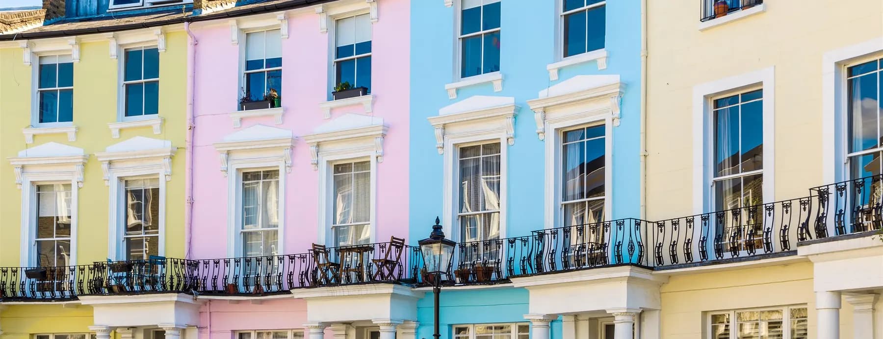
Painted stucco terracesCamden’s conservation area statement records the cream and pastel colours as part of what the designation protects, not a later fashion.
Every factual claim on this page was verified against a primary source on .
Camden Council · conservation areas, Article 4 directions, admissions, parkingDepartment for Education · every named schoolHistoric England · listed buildings and gradesGreater London Authority · protected viewsOffice for National Statistics · the price figures
Planning rules change. Camden replaced three of its Article 4 directions in June 2026. Anything on this page that turns on a planning instrument should be confirmed against the current one before you act on it.
Streets and characterOne conservation area, four quite different places.
Villas, terraces, a shopping street and an outlying crescent, each with its own rules of thumb
Primrose Hill is usually talked about as one thing. Camden's own conservation area statement divides it into four sub areas, and the distinction is worth knowing before you view, because what is normal in one is unusual in another.
Regent's Park Road South is villa dominated and comparatively low density: three and four storey houses set back behind gardens. The Central Area is the opposite, high density mid-Victorian terracing, typically three storeys over a basement, and distinctly urban in grain. Regent's Park Road North is the commercial stretch, the shops and restaurants that make the place function as a village rather than a dormitory. Gloucester Crescent sits apart to the east, a mix of villas and terraces with a character of its own.
Three estates, developed in sequence
The land came from three owners. The Southampton Estate supplied most of it, with Eton College holding the north and west and the Crown Estate the south. They were developed one after another through the middle and later nineteenth century, which is why the housing reads as a family rather than as a single design.
The painted stucco is not a fashion
People assume the pastel colours are a recent affectation. They are not. Camden's statement records that the stucco here is typically painted in cream or pastel shades, particularly on the villas and the grander terraces, where the effect is a unified composition running across a whole row rather than a set of individual houses. The brick beneath is London stock. The colour is part of what the designation protects, which is why repainting a single house in a run to stand out from its neighbours is the wrong instinct here.
What you may change
An Article 4 direction made on 3 March 1983 removed permitted development rights covering extensions and alterations, hardstandings and dropped kerbs, boundary walls and fences, and the painting of brickwork. It remains in force and was untouched by Camden's 2026 review of its other directions.
Two limits matter. It applies to single family dwelling houses only, so flats and converted buildings are not caught by it at all, which is a large share of the stock here. And it does not blanket the conservation area: Camden holds a list of the properties affected. Anyone who has bought in Belsize Park and assumes the same rules apply, or the reverse, will get it wrong. Check the direction against the specific address.
Planning position as at 4 September 2026
Camden divides the conservation area into four sub areas: villas and gardens at the southern end of Regent's Park Road, dense mid-Victorian terracing in the centre, the shops at the northern end, and Gloucester Crescent out to the east. The land came from the Southampton Estate, Eton College and the Crown Estate. London stock brick with stucco painted cream or pastel is the constant, and that colour is part of the protected character rather than a modern choice. The 1983 Article 4 direction applies to single family houses on a named list of properties, not to every address.
- Chalcot SquareThe set piece of painted terracing, and the image most people carry of the whole area.Central area
- Chalcot CrescentThe curved run, and the one most often photographed after the Square.Central area
- Chalcot RoadTerraces with shops at the eastern end, connecting through to Fitzroy Road.Central area
- Regent’s Park RoadTwo streets in one: villas and gardens to the south, the shopping stretch to the north.Sub areas one and three
- Fitzroy RoadLong north to south run through the centre, mixed terracing.Central area
- Princess RoadTerracing towards the eastern edge, close to the school.Central area
- Rothwell StreetShort and quiet, off Regent's Park Road.Central area
- Gloucester AvenueThe eastern boundary, carrying more traffic and backing onto the railway in parts.Eastern edge
- Gloucester CrescentDetached in feel from the rest, villas and terraces, its own sub area in the statement.Gloucester Crescent
- Elliott SquareModernist houses of the 1960s by Douglas Streeter, on the Chalcot Estate's Eton College land.Chalcot Estate
The hill and the viewSix views in London are protected. This is one.
Viewing Place 4A, two protected vistas, and an Act of Parliament from 1842
Primrose Hill rises to almost 63 metres and is among the highest points in Camden. The park is managed by The Royal Parks. The land became Crown property in 1841, purchased from Eton College by the Crown commissioners, and Historic England records that an Act of Parliament then secured it as public open space, the public being freely admitted from 1842.
The same pattern as Hampstead Heath, in other words: not a park that planning policy currently protects, but land secured long ago as public open space. One honest caveat, since this page is meant to be relied on. Unlike the Hampstead Heath Act 1871, which can be read in full on the statute book, we have not been able to identify the 1842 Act by name or citation. Historic England refers to it; no Act with Primrose Hill in its title appears on legislation.gov.uk. Treat the protection as well established and the precise instrument as unverified.
The view is protected by name
The Mayor's London View Management Framework, which sits under Policy HC3 of the London Plan 2021, designates six London Panoramas. Primrose Hill is one of them, alongside Alexandra Palace, Parliament Hill, Kenwood, Greenwich Park and Blackheath Point.
The summit is Viewing Place 4A, with Assessment Points 4A.1 and 4A.2, and two protected vistas run from it: one towards St Paul's Cathedral and one towards the Palace of Westminster. A development that would intrude on either has to be assessed against that framework before it can proceed.
This matters commercially and it is worth saying plainly to a buyer. The reason the skyline from the top of this hill looks much as it did decades ago is not luck or good taste on the part of developers. It is a named designation in the capital's planning framework, and it is why the walk up remains the single strongest reason people pay to live at the bottom of it.
Yes, and by name. Primrose Hill is one of six designated London Panoramas in the Mayor's London View Management Framework, under Policy HC3 of the London Plan 2021. The summit is Viewing Place 4A, and two protected vistas run from it: 4A.1 towards St Paul's Cathedral and 4A.2 towards the Palace of Westminster. The park itself became Crown land in 1841 and the public was admitted from 1842.
- Alexandra Palace Viewing Place 1A, the Viewing Terrace Panorama
- Parliament Hill Viewing Places 2A and 2B, on Hampstead Heath Panorama
- Kenwood Viewing Place 3A, the Gazebo, on the Heath Panorama
- Primrose Hill Viewing Place 4A, the Summit Panorama
- Greenwich Park Viewing Place 5A, the General Wolfe statue Panorama
- Blackheath Point Viewing Place 6A, the Point Panorama
Three of London's six designated panoramas sit on Tessa's own patch: Parliament Hill and Kenwood on Hampstead Heath, and Primrose Hill itself. There is nowhere else in the capital with that concentration, and it is the reason these skylines have not been built out.
Schools and admissionsA village primary at the centre of it, and everything else a bus ride away.
One very popular primary in a small area, and almost no catchment areas in Camden
Primrose Hill is smaller and more self-contained than the other three areas, and its schooling reflects that. There is a well regarded community primary in the middle of it, and beyond that families look outward, north into Camden's Hampstead provision or south and east into Camden Town.
Camden has no catchment areas bar one, at Abacus Belsize Free School, and that matters more here than anywhere. A small area with one very popular primary produces exactly the pattern you would expect: a short distance to the furthest child offered, and a noticeable effect on what people will pay to be near it. But that figure is a record of one admissions round, not a boundary, and Camden says plainly that it changes every year and that living closer than last year's furthest offer guarantees nothing.
The published figures sit in Camden's annual admissions guides. They are the only numbers worth looking at, and a property should never be bought on the assumption of a place that has not been offered.
Admissions position as at 4 September 2026
The independent sector is well served in every direction, with schools in Hampstead, Swiss Cottage, Highgate and central London all within a workable journey. Registration for the most competitive places is expected years in advance.
One popular community primary sits at the centre of a small area, which makes the distance to the furthest child offered unusually short and its effect on price unusually visible. Apart from Abacus Belsize Free School, Camden has no catchment areas, and that published distance changes every year. Beyond it, families look north into Hampstead or south into Camden Town, with the independent sector in Hampstead, Swiss Cottage and Highgate all within a workable journey.
- Primrose Hill School Mixed, 2 to 11. Community. In the area itself Proximity
- Christ Church Primary School, Hampstead Mixed, 4 to 11 CofE, parish first
- Fitzjohn’s Primary School Mixed, 3 to 11. Community Proximity
- The UCL Academy Mixed, 11 to 18. Adelaide Road Proximity
- Parliament Hill School Girls at 11. Mixed LaSWAP sixth form Proximity
- William Ellis School Boys at 11. Mixed LaSWAP sixth form Proximity
- La Sainte Union Catholic Girls at 11. Mixed LaSWAP sixth form Catholic first
- Acland Burghley School Mixed, 11 to 18. Community Proximity
- University College School Boys 4 to 16, co-ed sixth form. Frognal Selective
- South Hampstead High School Girls, 4 to 19 Selective
- The Hall School Boys, 4 to 13 Selective
- Devonshire House Mixed, 2 to 13 Selective
Admission arrangements, published distances and fees change every year. Check the current position with Camden and with each school directly before you rely on it.
Transport and parkingThe shallowest lifts on the network, and the longest frontage.
Chalk Farm in zone 2, and how Camden permits work here
Chalk Farm is the station, on the Edgware branch of the Northern line in zone 2. It opened on 22 June 1907, and it is Grade II listed. Its narrow wedge-shaped building gives it the longest frontage of any of Leslie Green's Underground stations, and it has the shallowest lift shafts on the entire network at twenty one feet.
That last detail is worth putting next to the other two guides. The whole Edgware branch opened on the same day in June 1907 and every station on it was designed by the same architect. Hampstead is the deepest station on the network at 58.5 metres, Belsize Park sits at 33.2 metres in the middle, and Chalk Farm has the shallowest lifts of any station anywhere on the Underground. Three stops, one architect, one opening day, and the two extremes of the network at either end of them.
Camden Town is a walk to the east and brings the Charing Cross branch and the High Barnet branch with it. Swiss Cottage on the Jubilee line is reachable to the north west. The buses along Regent's Park Road and Gloucester Avenue are good, and a great many local journeys here are made on foot, because the area is genuinely small.
Parking
Camden controlled parking zones apply throughout. Resident permits are priced by the length of the permit, the vehicle’s CO2 emissions band and its fuel type, with a further air quality surcharge on older petrol and diesel vehicles, so what you drive changes the cost substantially. You must be the registered keeper and live at the address at least five nights a week, and car free housing is not eligible.
A permit is valid only in your own zone. The Article 4 direction here explicitly covers hardstandings, so creating off street parking where none exists is not a matter of laying a driveway and hoping, and what already exists is worth more for that reason.
Chalk Farm on the Edgware branch of the Northern line, zone 2, Grade II listed, with the longest frontage of any Leslie Green station and the shallowest lift shafts on the network at twenty one feet. Camden Town and Swiss Cottage are both walkable for the other lines. Street parking needs a Camden resident permit, priced by duration and fuel type and valid only in your own zone.
- Chalk Farm Northern line, Edgware branch Zone 2
- Camden Town Northern line, both branches Zone 2
- Swiss Cottage Jubilee line, to the north west Zone 2
- Belsize Park Northern line, one stop north Zone 2
- South Hampstead London Overground Zone 2
Hampstead, Belsize Park and Chalk Farm all opened on 22 June 1907 and were all designed by Leslie Green. One is the deepest station on the network, one sits in the middle, and one has the shallowest lifts anywhere on it.
What things sell forA small area where the sub area does most of the work.
Why two houses of the same size a few streets apart are not the same house
Primrose Hill is small, tightly held and consistently in demand, which makes it less about broad market movements and more about the specific address. The sub area does most of the work.
In descending order, value sits with villas at the southern end, set back with gardens and the lowest density in the conservation area, then intact terraced houses in the central area, then flats in converted terraces, which is where most of the transactions actually happen, then flats above or beside the shopping stretch, which trade at a discount for the noise and the servicing that comes with a working high street.
The premiums here are particular to the place. A position in a complete painted run, rather than at the end where the composition breaks. Proximity to the park entrance, which is a short walk from almost everywhere but not equally short. A garden of real width in an area where many are narrow. Off street parking, which the 1983 direction makes hard to create. And a house that has not been carved up, because in an area this small the intact ones rarely come round.
The discounts are equally particular: backing onto the railway along parts of Gloucester Avenue, a position on a through road rather than a quiet one, short leases in the conversions, and any front elevation carrying work done without the consent the Article 4 direction requires.
Figures, London Borough of Camden
- Detached £3,606,000
- Semi-detached £2,125,000
- Terraced £1,569,000
- Flats and maisonettes £688,000
- All property types £833,000
Live: sales on this guide’s streets
- Sales in the 12 months to August 2026 24
- Median price, all sales £882,500
- Flats and maisonettes, median of 20 £727,500
- Semi-detached, median of 3 £2,650,000
Everything factual on this page comes from a primary source, and all of them are public. The conservation area, its four sub areas, the Article 4 direction, school admissions and parking zones: Camden Council. The protected view: the Greater London Authority's London View Management Framework. Prices: the Office for National Statistics and HM Land Registry.
Common questionsEight things people ask before they view.
Short, sourced answers on the view, the park, the paint and the planning rules
Is the view from Primrose Hill protected?
Yes, and by name. Primrose Hill is one of six designated London Panoramas in the Mayor's London View Management Framework, which sits under Policy HC3 of the London Plan 2021. The summit is Viewing Place 4A, with Assessment Points 4A.1 and 4A.2, and two protected vistas run from it: 4A.1 towards St Paul's Cathedral and 4A.2 towards the Palace of Westminster. Development that would intrude on either has to be assessed against that framework first.
Can Primrose Hill park ever be built on?
The land became Crown property in 1841, when the Crown commissioners purchased it from Eton College, and Historic England records that an Act of Parliament then secured it as public open space, with the public admitted from 1842. It is managed by The Royal Parks. Note that, unlike the Hampstead Heath Act 1871, the 1842 Act cannot be identified by name or citation on the statute book, so treat the protection as well established and the instrument itself as unverified.
Why are the Primrose Hill houses painted in pastel colours?
Because the stucco was always meant to be painted. Camden's conservation area statement records that stucco here is typically painted in cream or pastel shades, particularly on the villas and the grand terraces, where it creates a unified composition across a whole run of houses. The colour is part of the designated character, not a later fashion.
Is Primrose Hill a conservation area?
Yes. It was designated on 1 October 1971 and extended on 18 June 1985 to take in north Erskine Road. Camden adopted the current conservation area statement in December 2000. The area is divided into four sub areas: Regent's Park Road South, the Central Area, Regent's Park Road North and Gloucester Crescent.
Do I need permission to alter a house in Primrose Hill?
Possibly, and two limits matter. An Article 4 direction made on 3 March 1983 removed permitted development rights covering extensions and alterations, hardstandings and dropped kerbs, boundary walls and fences, and the painting of brickwork. It applies to single family dwelling houses only, so flats and converted buildings are not caught, and it covers a list of properties held by Camden rather than the whole conservation area. It is older and differently drawn from the Belsize direction, so do not assume the two work the same way.
How high is Primrose Hill?
Almost 63 metres, which makes it one of the highest points in the London Borough of Camden. The Royal Parks give the summit as just under 63 metres above sea level.
Which station serves Primrose Hill?
Chalk Farm, on the Edgware branch of the Northern line in zone 2. It is Grade II listed, opened on 22 June 1907, and has the longest frontage of any of Leslie Green's Underground stations along with the shallowest lift shafts on the network at 21 feet. Camden Town and Swiss Cottage are both within reach on foot.
What sort of houses are in Primrose Hill?
Mid to late nineteenth century, and they change with the sub area. The southern end around Regent's Park Road is villa dominated and lower density, set back behind gardens at three to four storeys. The central area is high density mid-Victorian terracing, typically three storeys over a basement. London stock brick with painted stucco is the constant.
Thinking of selling in Primrose Hill?
An honest figure based on what has actually sold on your street this year, not a number designed to win the instruction and then be reduced in six weeks. Valuation, viewings, negotiation and progression, all with the same person.
Tessa will get back to you as soon as possible.